| About Us | Partner Organizations | Focus Areas | Policy Initiatives | Publications and Documents |
| About Us | Partner Organizations | Focus Areas | Policy Initiatives | Publications and Documents |
The extensive resources of the AIRMAP program have been leveraged to facilitate successful implementation of regional measurement under NCASP.
Focus Area:
Regional Measurements
AIRMAP:
The NOAA-sponsored AIRMAP air quality and climate program is based at UNH and its extensive resources have been leveraged to facilitate the successful implementation of a regional measurement program under NCASP.
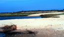
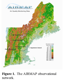 AIRMAP has established three long-term measurement sites for documenting and studying persistent air pollutants such as ground-level ozone and fine particles on various time scales in the New England atmosphere. These sites span a 200km north-south transect across New Hampshire and provide a gradient in elevation from sea level (Appledor Island, Isles of Shoals) and (Thompson Farm in Durham) to 400 m at castle springs (Moultonborough) and up to 2300m at the summit of Mount Washington (North Conway). The Durham site is heavily equipped for measuring critical air pollutants in the non-urban atmosphere. Most species are measured on a minute time basis with the suite of VOC's at once per hour. Near-real-time data for many of these parameters can be viewed at www.airmap.unh.edu.
NCASP Measurement Program:
We plan to use existing tall towers in the Northeast as sampling platforms for additional measurements of the regional and global pollutants carbon dioxide (CO2) and mercury (Hg). These towers will be located at sites to facilitate determination of the influx/outflux of CO2 and Hg, as constrained by the availability of towers and our access to them. The idea is to populate 4-5 tall towers with our instrument package over the next several years. (Click here to see a conceptual picture of the regional observing system).
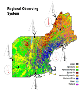 Our initial goal will be to instrument two towers with a vertical profiling capability. Initially, we hope to instrument a 190 m tower in Portsmouth, NH. Carbon monoxide (CO), CO2 , O3 , and Hg would be measured continuously at the 190 m height with 5 minute time resolution ( i.e.., the time frame of the Hg measurement). We will use CO as a general combustion tracer and to facilitate estimation of anthropogenic CO2 . To improve surface exchange parameters of heat and water vapor in our RCMS, small ecosystem flux towers (Campbell Scientific) will be placed in key ecosystems throughout the region. (The Regional Observing System).
 |